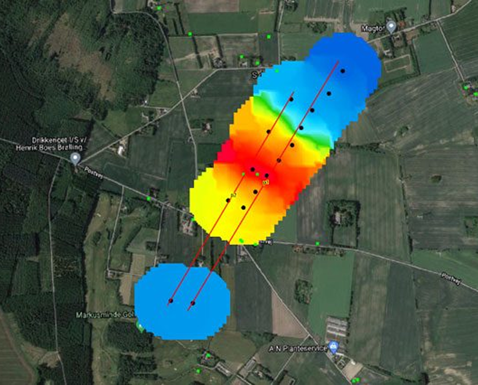
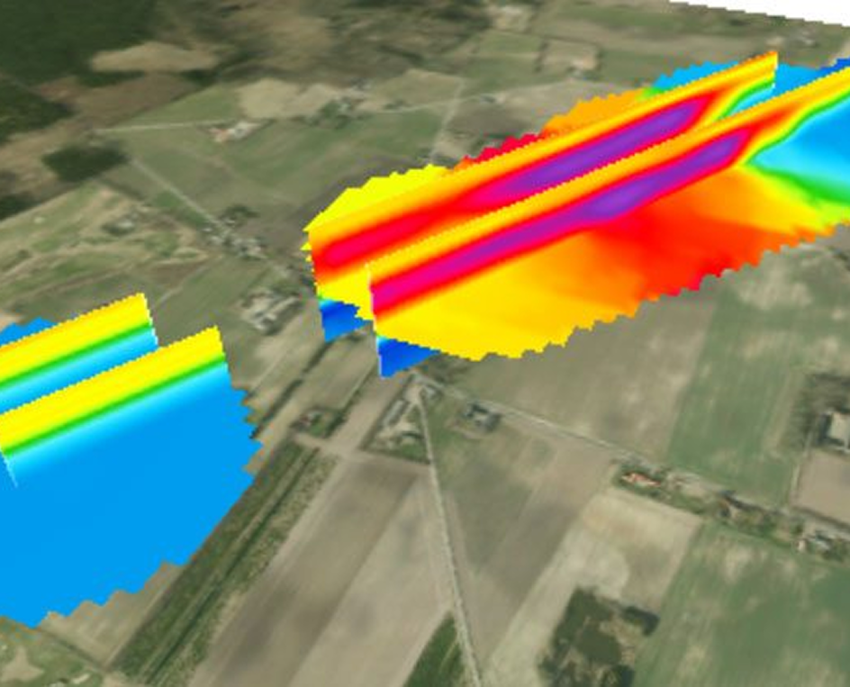
Faster groundwater, mineral and environmental surveys

The ABEM WalkTEM 2 is a user-friendly, rapid survey solution that can provide precise resistivity models directly in the field for the search, mapping and monitoring of groundwater, mineral deposits, and environmental change.

REQUEST QUOTE

Application Areas

Groundwater

A high sensitivity to conductive materials makes TEM extremely useful in groundwater studies, for example differentiating between fresh, brackish and saline deposits, monitoring drawdown and recharge of an aquifer, or simply estimating its extents by building up profiles or grids of soundings.

Environmental

TEM provides a rapid means of surveying for a range of environmental applications from identifying potentially hazardous clay units within a geological sequence, to mapping and monitoring dynamic features such as permafrost thickness or pollution plumes.

Minerals

TEM responds well to conductive mineral bodies. With multi-component measurements and the ability to determine chargeability from IP effects in TEM data (using Aarhus SPIA TEM), the WalkTEM 2 is a powerful tool in the search for new mineral deposits.

Features

PRECISE RESULTS FROM SUPERIOR DATA QUALITY

Every aspect of the ABEM WalkTEM 2 has been designed with a focus on optimizing data quality.

Clean, precise TEM data is measured seamlessly from shallow to deep thanks to Dual Moment measurements, broad dynamic range, robust ABS polymer housings and separate, yet compact, transmitters and receivers.

TEM resistivity profile

TEM resistivity profile

TEM resistivity depth slices 2D

TEM resistivity depth slices 2D

TEM resistivity depth slices 3D

TEM resistivity depth slices 3D

RAPID FIELD SURVEY PROCEDURES AND ANALYSIS

With a focus on efficient operation, it is possible to map in minutes what could take hours or days with other geophysical technologies or drilling.

The ABEM WalkTEM 2 combines features such as the unique Dual Moment measurement mode with multiple receiver channels to enable collection of parallel data streams in a single measurement cycle. After data collection is finished the results can be modelled directly on the instrument so that quality assurance measures, and even an initial geological interpretation, can be done without need for a laptop or a return to the office.

groundwater, mineral and environmental surveys

A FLEXIBLE AND VERSATILE SURVEY SYSTEM

The ABEM WalkTEM 2 represents the ultimate scalable system that should fit any customer’s survey requirements or budget and a broad range of applications.

The modular product range includes two receiver and three transmitter options, plus an array of transmitter and receiver loop choices with the larger systems capable of reaching depths in excess of 800m. Specification upgrades can be purchased and installed remotely with ABEM’s unique hardware licensing system, which allows the WalkTEM’s capability to grow in line with your changing needs.

groundwater, mineral and environmental surveys

From the left: TX 8/20, RX, TX 60

SPIA-Data-Example

EASY AND EFFICIENT SURVEYING

A simple field set-up combined with a light and intuitive user interface, quick analysis tools and Bluetooth notifications allow for easy configuration and data collection in the field.

Even the more complex aspects of setting up a measurement have been simplified with internal damping for ‘tuning’ the transmitter loops to the on-site conditions, so no more lost or forgotten resistors. An analysis tool will test and display results from all the damping resistors so that even less experienced TEM users can make the right choice to get optimum results every time.

Hardware

A RUGGED SYSTEM MADE FOR THE FIELD

The WalkTEM 2 follows in the ABEM tradition of developing light and nimble systems with exceptional go-anywhere build quality.

The system boasts an IP66 classification, even during measurement, and with robust housings, rugged connectors, a 6mm shatterproof screen and a wide operating temperature range you can operate in even the harshest conditions with confidence.

groundwater, mineral and environmental surveys


1. 6mm toughened glass display

2. Durable high specification connectors

3. Hot-swappable internal RX batteries

4. Protective rubber bump strips

5. Rugged dust and water proof IP66 casing

6. Integrated GPS


The TEM method is perfectly suited to locating groundwater and minerals, but also useful for applications such as geological mapping and environmental surveys.

LEARN MORE ABOUT TEM

Video Content


Contact us for expert help

  • This field is for validation purposes and should be left unchanged.