What is TEM?
TEM (Transient Electromagnetics) is a geophysical technique used to obtain vertical resistivity soundings and a method which responds most strongly to conductive materials.
The method is non-destructive and uses a series of wire loops for transmitting and receiving signals in the ground so no marks will be left in the survey area after measurements are finished.
The TEM procedure is remarkably efficient: with just a 40×40 meter square transmitter loop and 1 or 2 smaller receiver coils, it is possible to reach depths of 200-250 meters and to get from setting-up to a resistivity model only takes a few minutes. With a suitable system configuration, it is possible to reach depths of more than 800 meters, without a huge increase in survey times.
Application areas for Transient Electromagnetics
Transient Electromagnetic (TEM) methods are unmatched when the goal is rapid, deep-penetrating detection of conductive layers.
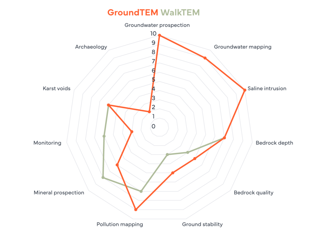
As the diagram clearly shows, TEM is an excellent tool for Groundwater Prospection (10/10). Its ability to work without direct ground contact (using loops) allows the user to cover large areas fast, making it a great choice for regional Groundwater Mapping (9/10).
TEM also excels in detecting Saline Intrusions (10/10), where it can precisely map the interface between fresh and salt water at depths that other surface methods struggle to reach. It also shows solid performance in Mineral Prospection (8/10 for ABEM WalkTEM 2) and Pollution Mapping (9/10 for ABEM GroundTEM).
However, TEM has distinct physical limitations. It is not designed for ground stability (3-5/10) or archaeology (2/10), as these applications require high-resolution imaging of resistive or mechanical properties rather than bulk conductivity. Similarly, while it can detect bedrock depth (7/10), it is generally used for this purpose only when a high conductivity contrast exists between the overburden and the rock.
Why do I need a system?
The TEM method is perfectly suited to locating groundwater and minerals, but also useful for applications such as geological mapping and environmental surveys.
The WalkTEM instrument from ABEM has such a high sensitivity to conductive materials that it is possible to detect the difference between fresh, saline and even contaminated water. This significantly minimizes the risk of drilling wells in the wrong place or too deep and encountering saline water, for example. Furthermore, by collecting multiple soundings along a profile, or across a grid, it is possible to begin quantifying the targets being mapped.


How does Transient Electromagnetics work?
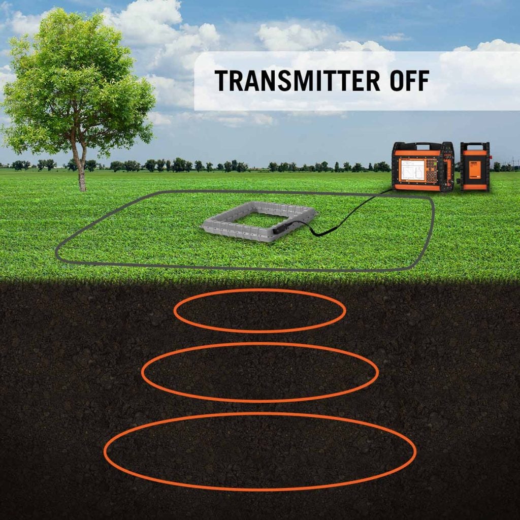
TEM is an inductive method, which means that it does not require a direct galvanic (electrical) contact with the ground. A transmitter loop on the ground induces a transient current within the subsurface and the receiver antenna(s) then measure the rate of change of the magnetic field associated with that current as it propagates through the earth.
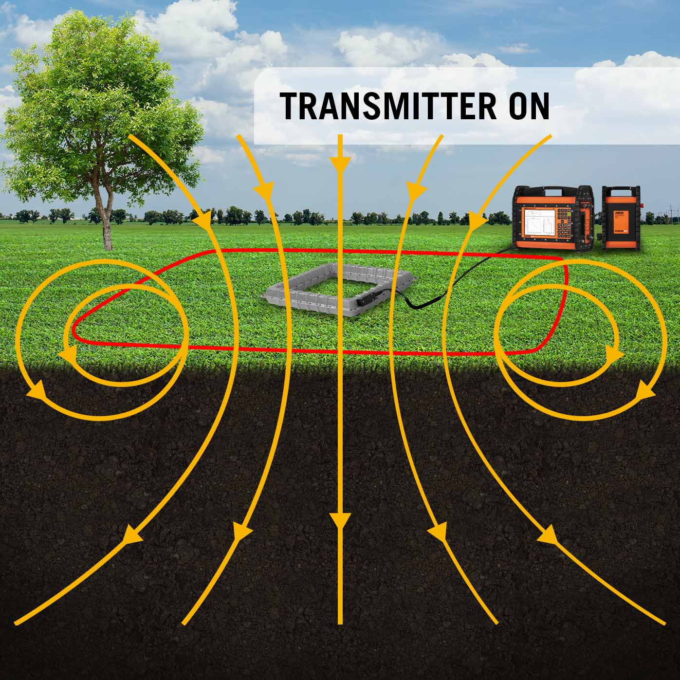

Current flowing through TX Loop (red) create a magnetic field (yellow)
The collapsing magnetic field creates electrical currents in the ground (orange)
Ground currents create a secondary magnetic field (yellow) recorded by the RX coil (centre)
Transmitter loops and receiver coils are available in different sizes depending upon required depth penetration. Small transmitter and receiver loops are suited to shallow responses, larger loops are better at recording the deeper responses.
The collected raw data may be inversed directly on the instrument (or externally), giving a resistivity model of the investigated site.

The figures above show two examples of how TEM survey data can be presented. On the left is the end-result from a single measurement: a 1D resistivity model. The red line indicates how resistivity values change from the surface (at the top) to just beyond the reliable depth of investigation (green horizontal line). As the red line moves to the right, it indicates higher resistivity; as it moves to the left, it indicates lower resistivity. Those resulting values are then the basis for an interpretation – either identifying different geological materials or identifying how the response from those geological materials is altered by deposits within them. For example, lower resistivity is associated with electrical currents flowing more easily through mineral deposits or regions with increased water content.
On the right is a 2D profile, over a buried former river channel, made up of data from a series of 1D soundings along a line to provide a more continuous picture of how resistivity varies across a larger area. Depending on the layout of the measurements taken, we can build ‘maps’ of resistivity across an area at a specific depth, a map of depth to a particular layer, or 3D models.
When does Transient Electromagnetics not work?
TEM technology is sensitive to electromagnetic noise and so it may not be an appropriate method at certain locations. In general, urban environments are unsuitable for TEM instruments due to potential noise sources (e.g. buildings, utilities, other infrastructure) and the inevitable likelihood of bad data. A rule of thumb is that any noise source should be no closer than two times the transmitter loop side: so, for a 100×100 meter loop, it is recommended that no potential noise sources are located closer than 200 meters from any side of the outer loop.
TEM is also not the most appropriate method to use for mapping (near-)vertical or laterally confined structures, e.g. aquifers in near-vertical jointing / fracture zones or laterally confined mineral seams. The use of multi-component data and collecting multiple soundings along a profile may be a solution to the problem but other methods, e.g. ERT, would be more suitable.
Related Products
- ABEM WalkTEM 2 – For faster groundwater, mineral and environmental surveys
- ABEM GroundTEM i-Series – A TEM-system with great affordability & ease-of-use
- ABEM GroundTEM Trek – A backpack-mounted mobile TEM solution
- ABEM GroundTEM Ralli – A mobile TEM solution for rapid groundwater and environmental mapping