Two big differences between refraction and reflection survey are, firstly, which part of the seismic motion we focus on and, secondly, the type of result we will get. In refraction surveys we are most interested in the seismic waves that are travelling laterally, whilst for reflection survey it is the (near-)vertical propagation we look for. Refraction surveys provide us with a layered velocity model as our primary output, reflection surveys will create a ‘true’ image of stratigraphy and structure, with a velocity model requiring further processing. Both methods are responding to interfaces (horizons) where the density and elastic properties of the subsurface material change.
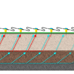
Refraction seismic (click to enlarge image)
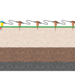
Reflection sesimic (click to enlarge image)
Refraction surveys:
- Are commonly used for predicting depth to bedrock, rock strength/rippability, layer thickness, identification of faulting/fracture zones, soil stability, landfill investigations;
- Provide p-wave (pressure) velocities in soils and bedrock providing a quantitative result;
- Use a field procedure and processing workflow which is relatively straightforward;
- Only require an accurate record of the first arrival at each geophone which makes survey in urban areas (where there may be sources of noise) less problematic;
- Require inversion to produce the final result, so it is only a predictive model of what the ground could ‘look’ like;
- Require the ground velocity to increase with depth so, if you have a high velocity layer above a low velocity layer, the use of refractions seismics should be reconsidered. This can be an issue in cold climates where the top layer is frozen.
Reflection surveys:
- Are regularly used for mapping layer thicknesses, bedrock level and topography, horizon profiling, void and sinkholes, mapping faults and horizontal fracture zones, and where high detail is necessary or it is a ore complex geological environment;
- Theoretically provides a ‘true’ image of subsurface stratigraphy;
- Will still work even if a high a velocity layer lies above a low velocity layer;
- Requires many more shots and/or receiver locations than refraction survey and more complex data processing;
- Will be hard in ‘noisy’ environments to get a good result.
More to read
Application areas
https://www.guidelinegeo.com/application-areas/
Methods
https://www.guidelinegeo.com/seismic-methods/
Case Stories
https://www.guidelinegeo.com/solutions/case-stories/
Products