The views and opinions expressed, are those of the author(s) and do not necessarily reflect the official policy or position of Guideline Geo AB
The IPCC (Intergovernmental Panel on Climate Change) released its climate report in August 2021 against a backdrop of unusually heavy rains, flooding, drought, high temperatures and fires that have raged around the world throughout the summer. Additionally, this year we hit our ‘budget’ for resources from the planet, known as the Overshoot Day, on 29th of July, a month earlier than in 2020. This means that for August, September, October, November, AND December we are living above our means.
Where are we heading? Well, I am heading towards trying to give some examples of how geophysical investigation techniques can aid in mapping and monitoring of waste, so it can be reused, recycled, or protected for our future.
Bikes and Wenner
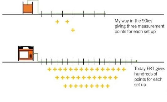
In 1998 when I started my PhD work, I didn´t have any driving license. But I had a bike. And was fortunate to be living in Stockholm, Sweden with plenty of safe commuter trains and buses. I also had confused thoughts on how to monitor groundwater. Two days of training during my MSc education had opened the eyes to this strange world of geophysics. I really fell in love. So, me, my bike, a home built Wenner-configured cable, with two different cable lengths, and an ABEM SAS 300 went around to different locations to not only monitor the normal seasonal variation of resistivity, but also to check on salt spreading from winter roads and map leachate around landfill areas. Sometimes I added a conductivity meter, an old EM38, to cover more ground. I travelled lightly with not much more than some spare crocodile clips and electrical tape in my pocket and enjoyed the outdoor work even if it resulted in comparably few data points, from only two different depths of ground at the various locations. The most important conclusions I drew was that geophysics is an incredibly useful tool, and it is very fun too!
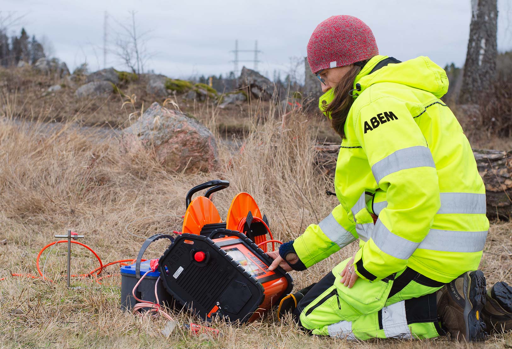
Since then, instruments have undergone much development; fast forward to today and now resistivity measurements give you an excellent opportunity for monitoring in more detail both laterally and vertically with so called ERT (Electric Resistivity Tomography) measurements. You do not even need to be outdoors anymore!!! There are systems installed, with permanently placed cables and electrodes, continuously mapping the ground and you just make a simple call to check on the conditions or get an automatic warning if the resistivity is deviating. Nice and easy and so much better than only irregularly sampling sparse points.
Finding both treasures and scrap
Often, where you have waste or contamination, you also have ‘treasures’. What was waste before can today be a treasure, like metals or rare earth elements or maybe a useable groundwater resource underneath a contaminated industrial site. And resistivity is an amazing tool for both treasure and scrap hunting, so use it for:
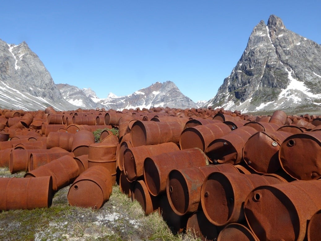
- Mapping landfill and waste dumps: Alarmingly often, we forget where we dumped our waste or how much we´ve dumped. This information is needed both when settlements expand, so we do not build housing areas on the wrong location, and also if we want to go on a scavenger hunt and start a waste mining operation. Resistivity will provide an efficient tool to delimit the borders and thickness of the dump areas.
- Mapping gas: When you have found your waste, you can start mining gas! This gas can be used for heating of housing areas or to drive the local bus. Resistivity can also be used for monitoring the fluctuation of gas within landfills.
- Sort out metal: If you combine resistivity measurements with IP measurements (actually these are done with the same instrument and at the same time -> perfect!) you get different responses from a waste dump if it contains only domestic waste or also metal. The IP response will point directly to volumes containing more metal, so you get a hint of where to mine.
- Mapping contaminations: As already said, resistivity is excellent for road salt and landfill leachate. But also for other ground contaminants such as oils and a variety of chemical substances. Find the areas and clean or contain them, before the contamination destroys valuable groundwater resources, natural habitats or agricultural land.
- Mapping saltwater intrusion: Even if completely natural, sea water is a source of contamination in many coastal areas. It mixes up with the fresh groundwater and when a drinking water well has started to take in salt water it takes a long time to restore the fresh groundwater storage. Your coffee will not taste as it should… Did you know Resistivity and TEM can efficiently aid in mapping areas with saltwater intrusion and also monitor the same; is the area of intrusion growing or shrinking?
- Mapping groundwater: Groundwater can be contaminated, but also clean, or more or less clean, so even in areas with plenty of constructions, roads and people, there might be usable groundwater hidden below the ground surface. Or far off, in a desert‐like environment. Resistivity and TEM can be excellent tools to find areas with groundwater.
and hide them again
Once you have found the treasures, you are stuck with the remaining scrap. This waste needs to be taken care of in a way that it will not harm our environment. Not today, not tomorrow, not ever. In the process of ‘hiding’ our waste, all geophysical methods GPR SEIS RES TEM will provide outstanding information regarding some aspect of the subsurface conditions, such as soil layering, depth to bedrock, soil types, and groundwater levels. This is information is needed, in for example, the planning of new landfills or safe deposits.
Further on in the life-cycle of the site geophysics can aid in:
- Mapping of landfill covers: The cover of a landfill should be whole, without cracks were rain water can sneak past and result in a groundwater contamination. Resistivity and GPR can be used to check the quality and thickness of the cover.
- Mapping natural barriers: When building a road or a railroad the risk of accidents is following. Accidents that may not only affect human life but also the environment in the form of effluent from tankers, liquids used for cleaning-up etc., which can harm groundwater and the wider natural environment. To prevent this from happening it is good to map clays and other dense soils that will provide a natural barrier if an accident happens and point out areas where artificial protection may be needed.
- Monitoring dams: Sometimes you hide your waste in dams, as a sedimentation dam outside a mining area. The function of the dam can be monitored with especially resistivity but also GPR investigation, for weak points and leachate. And when talking about monitoring, resistivity and GPR can also be used to see how a cleaning operation of a contaminated ground is finalized.
- Mapping the bedrock: As you all know, spent nuclear fuel is some of the most dangerous waste we have. And this needs to be handled in a safe way. Deep depositories are constructed and borehole GPR can give information on fractures in the rock volume as well as groundwater inflow and changes of bedrock type. Resistivity in boreholes also give important information on the rock mass and groundwater presence.
To conclude
When you are ready with your safe and sound waste deposit, use the geophysical methods, especially resistivity, to monitor your scrap so it will not do any more harm. Our focus can be around or on a landfill, but also along roads, by the coastline and around mining dams. I guess that most of us agree that this is our planet and not a waste dump. And that we, on all levels, can do something to change the direction of both the IPCC´s future reports and the date of the Overshoot day. So here is geophysics, once again, being part of a local solution to a global problem.
P.S. If you want to read more about early days of resistivity monitoring check THIS out.


Jaana Gustafsson, Applications Specialist, Phd
The views and opinions expressed, are those of the author(s) and do not necessarily reflect the official policy or position of Guideline Geo AB