Description: Archaeological Geophysics
The buried archaeological features on a single site are often of different ages and sizes. Some are fragile, some are large, many are hidden below ground and generally not easy to move or investigate without damaging or destroying the archaeological features themselves. Archaeological remains are found in all types of geological surroundings and can differ from small, subtle post holes or hearths to more significant buried or still-standing masonry structures related to previous human occupation at a site.
Classic archaeological methods such as trenching and using brushes and shovels also require a lot of labour and energy. It will not be cost- or time-effective and can in a worst case scenario fail to secure, damage or even destroy remains and artifacts.
In order to thoroughly investigate the plethora of different archaeological remains, archaeologists often complement the traditional excavation methods with other scientific tools, such as soil chemical analysis or non-destructive geophysical prospection methods. An integrated approach, using many different methods at the same site, will invariably be the only way of solving the complex mysteries of the past.
Using different geophysical techniques, it is possible to perform 2D and 3D investigations of a site before you start digging. From the mid-20th century onwards a wide range of geophysical techniques (i.e. magnetics, resistance/resistivity, ground-penetrating radar (GPR) and other EM instrumentation) have been added to the list of suitable methods for archaeological investigation.
At Guideline Geo, we offer a wide range of non-destructive geophysical solutions for archaeological site surveys; ground-penetrating radar (GPR), resistivity tomography, and IP/SP. Whether you're studying buried foundations, cultural heritage remains, or mapping landscape features, our integrated geophysical techniques deliver high-resolution subsurface data to guide efficient excavations.
Andreas Viberg, PhD, Product Manager MALÅ

Earlier version of the MALÅ MIRA GPR system at a Stonehenge GPR survey (© LBI ArchPro)
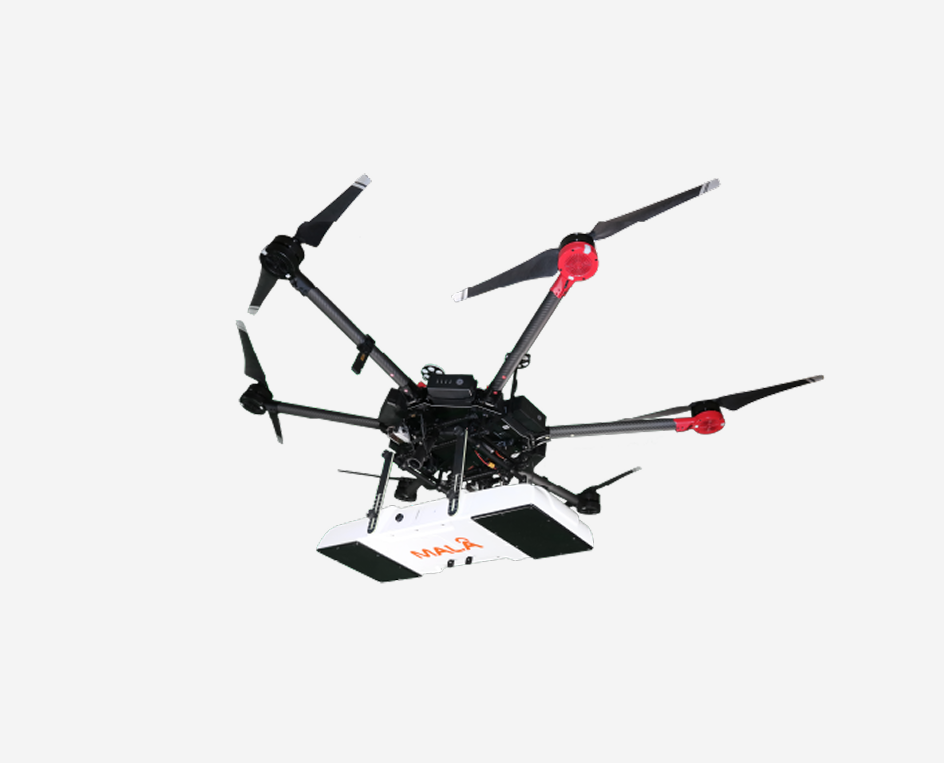
Large-scale application of non-invasive, high-resolution archaeological prospection methods have revolutionized archaeological prospecting during the last decade, and MALÅ MIRA GPR has been central in this advancement. Regardless if we are investigating the surrounding of Stonehenge or looking for buried Viking ships in Norway, huge 3D data sets have been gathered over vast areas and resulted in finding formerly unknown, otherwise invisible, archaeological monuments and sites.
Find Out More About our MALÅ MIRA Instruments:
- MALÅ MIRA HDR – Large-scale 3D GPR mapping. Multiple carrier solutions for maximum operational flexibility.
- MALÅ MIRA Compact – 3D GPR mapping in a compact format.
- MALÅ MIRA Flex – A modular, custom-built 3D ground-penetrating radar (GPR) array.
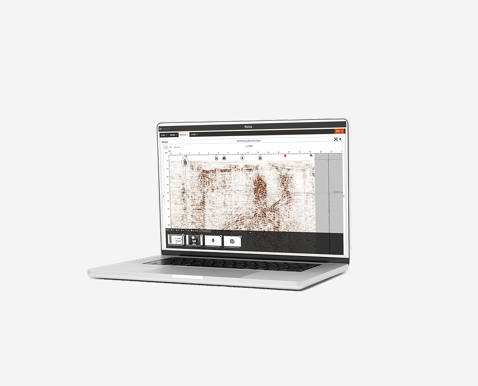
Pond view from MALÅ Vision showing MALÅ MIRA HDR data from Brancaster Roman fort in the UK.
Geopysical Methods for Archaeology
Guideline Geo’s wide range of different geophysical investigation techniques can form an integral part of archaeological investigation strategies. Geophysical techniques provide a non-destructive way of assessing what lies beneath the ground or within a particular structure. The data coverage when using geophysical survey techniques is also often better compared to point-wise sampling and digging, which makes the investigations more cost-effective and less time-consuming. With the addition of motorised geophysical solutions, entire archaeological landscapes can be surveyed in a short amount of time.
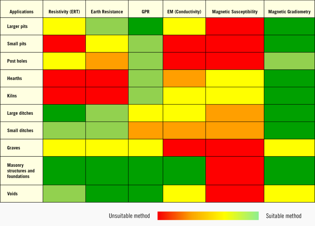
In Table 1 common archaeological features and objects are listed and matched to a range of suitable geophysical methods. Among these, Guideline Geo offers solutions for GPR and Electrical Resistivity Tomography (ERT), including Induced Polarization (IP) and Self-Potential (SP) measurements.
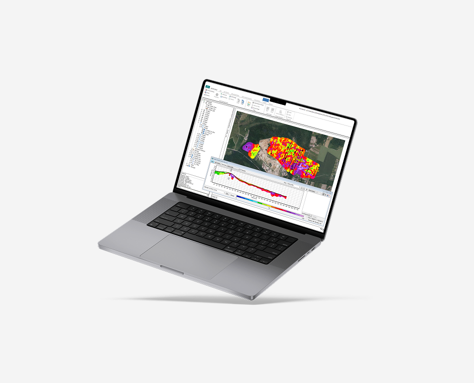
The geophysical solutions will provide an easy-to-use output as images of the measured physical parameters or provide a position (XY) and depth (Z) to, for example, layers, objects and anomalous zones which are then easily transferred to either GIS or CAD applications.
Table 1: Common survey targets and applicable methods
Ground Penetrating Radar for Archaeology (GPR)
GPR, or ground penetrating radar, is an efficient investigation technique for different archaeological targets and applications, both in rural and urban areas. GPR investigations are most often carried out in open and/or flat areas but can, with a suitable carrying solution, also be carried out in most other terrain types.
The choice of frequency for your survey would depend on the size and type of archaeological feature you are aiming to map but also on the required resolution and depth of your survey. For most investigations, aiming to locate archaeological features in the upper 2-3 meters, a frequency of around 500 MHz is usually suitable.
As seen in Table 2, the resolution changes with antenna frequency. This is also true for increasing depth, meaning that objects need to be larger, at depth, to be detectable.
(*values seen in common soils and geology; significant improvements may be experienced in other media such as clean sands and frozen ground.)
| Antenna Frequency (MHz) | Suitable Target Size (m) | Approx. Depth* (m) |
| 450 | 0.06 | 4-5 |
| 750 | 0.03 | 2-3 |
| 1200 | 0.02 | 1-2 |
| 2300 | 0.01 | 1 |
Table 2: Resolution in relation to antenna frequency
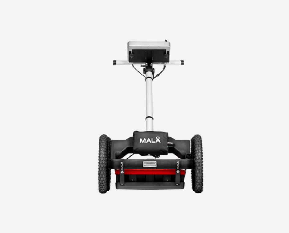
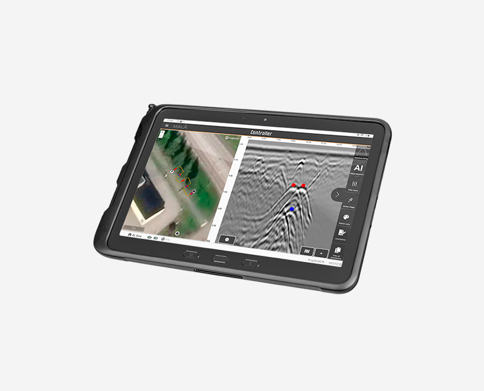
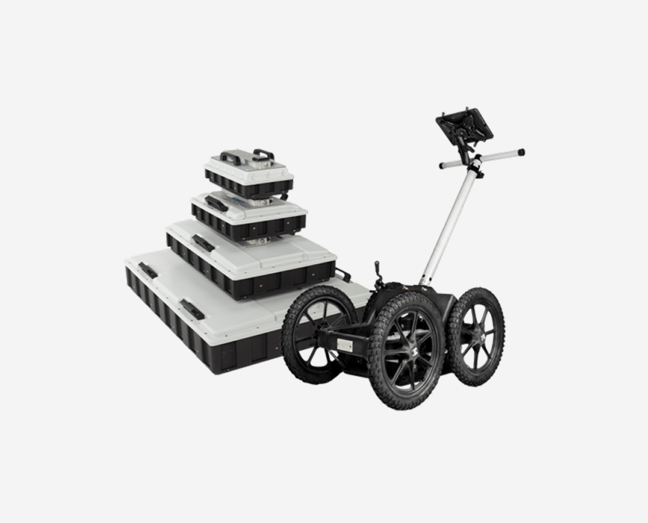
GPR measurements for archaeological investigations are commonly carried out by pushing the antennas in a cart along predetermined parallel lines on the ground or on a wall, covering the area of interest. During an investigation, the position of the GPR antenna, in the field, can additionally be tracked by an external or internal GPS depending upon the required accuracy. It is often also recommended to use guide ropes on the ground to make sure you are surveying in the right place and following straight lines over your designated survey area.
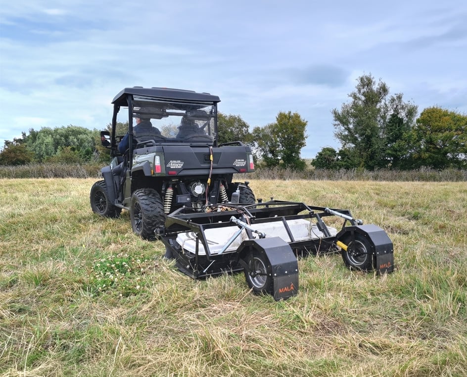
The MIRA HDR is a cost-effective 3D GPR array, optimized for mapping large areas to locate buried objects and artifacts.
GPR investigations can be carried out both as 2D and/or 3D projects. Single channel 2D GPR is often suitable for smaller sized archaeological projects but, when the investigation area gets larger, and particularly when the layout of the buried artifacts gets more complicated, a multi-channel array solution will be a more efficient option.
Read more about this in our help articles:
How should I carry out 2D GPR measurements to find old building remains?
GPR Results for Archaeological Investigations
For archaeological investigations, the results are often presented as time-slices, a map of the subsurface conditions at different depths. These are sometimes referred to as depth-slices or amplitude maps.


See when the MALÅ MIRA HDR returns to Brancaster to survey the whole site in just one day.
Resistivity for Archaeology
Electrical methods, like Resistivity & Induced Polarization, are efficient investigation techniques for a number of different archaeological applications and are used mostly in rural areas (without asphalt, concrete etc.). Resistivity investigations are carried out in the field but can also occasionally be applicable inside, on floors, walls and other structural elements of an historic site.
Typically, electrical methods fall into two categories: those which simply measure bulk resistance across an area and those which create a resistivity model in 2 or 3 dimensions (so called ERT, electrical resistivity tomography). For the former, it is common for dedicated archaeological systems to use “twin probe” measurements (with two mobile electrodes and two remote electrodes) to measure the earth resistance for a certain ground volume. Measurements are done in grids with a point interval of approximately 0.5 or 1.0 meter and the results presented as a map of resistance variation across the area.
ERT measurements are done in profiles where the electrode spacing is selected according to the resolution wanted. The spacing for archaeological investigations is often 0.5 to 2 meters. These single 2D lines can be combined into 3D volumes if made parallel (and often referred to as 2.5D survey) or data can be collected in a 3D grid from start. The latter gives the best representation of the targets being investigated but are more often impractical for large survey areas. As a result, the 2.5D methodology is probably the most common approach.
Whereas the resistance methods are used for general search and mapping of archaeological deposits, resistivity is employed in specific cases, normally where greater depth is required, or where being able to visualise a cross-section or 3D model of a feature is beneficial, or where the topography of the feature might be extreme. Common targets for resistivity are burial mounds and tumuli, ditches (mapping the profile or looking at variation within the fill material), deep foundations (including foundations beneath extant standing structures), and embankment material. Resistivity methods will often be employed where GPR cannot be used either because of the depth requirement or where soil type will cause GPR systems to perform poorly.

Flexible, easy to use and boasting a number of innovative features the ABEM Terrameter LS 2 is the ideal partner for geotechnical surveys and research work.

Investigating subterranean structures around standing remains
IP and SP for Archaeology
When resistivity measurements are carried out, the IP (Induced Polarization) response can be recorded simultaneously with the same equipment to produce a plot of chargeability. So rather than measuring the voltage in the ground whilst the current is flowing from a resistivity meter (and then calculating resistivity values) the instrument will look at how voltage varies during the time when the current is being switched on, off or changed from one polarity to another. Archaeological deposits can affect the rate of this change.
SP (Self Potential) measurements are done separately but with the same equipment as resistivity and IP investigations.

Slight elevations in chargeability are caused by IP effects from a network of wooden trackways
Other Geophysics-Techniques for Archaeology
A number of other methods are employed in archaeological prospection (as highlighted in Table 1) but from the Guideline Geo range of products it is primarily the GPR and Resistivity systems which would find use in this area.
- TEM does not provide sufficient detail as a 1D sounding method nor the requisite resolution to target archaeological remains directly. However, the mapping of buried landforms and using these as indicators of where archaeological resources may exist is a viable application for the method. Also mapping how anthropogenic activity has modified a landscape might be possible with TEM.
- Seismic methods have been used upon occasion to investigate larger archaeological forms such as burial mounds and some searches for subterranean structures, but it is a limited field. Again, as with TEM, there is the potential for mapping landscape scale features associated with archaeological activity rather than the activity itself.

Wooden trackways, within peat bog in Ireland, are only discernible through IP measurements – their resistivity signature is indistinguishable from the surrounding peat. [Data and images courtesy of Earthsound Geophysics and Wolfhound Archaeology]
What Method and Technique to Use?
There are many different aspects when choosing the method for archaeological applications. Often you combine several methodologies. Some important points to consider are, however:
- Rural or urban If the investigation site is located in urban areas, it can be difficult to ground electrodes in a proper way, which makes GPR a more suitable method than resistivity.
- Size of artifacts/remains If the size of the remains investigated are small (approx. <2 meter) GPR most often provide higher resolution results compared to resistivity.
- Geological conditions If the ground conditions are conductive (due to for instance clay, saltwater) the electromagnetic waves from the GPR are efficiently damped and the subsurface information gathered can be sparse. Resistivity will work nicely also in conductive conditions.