MALÅ Vision
MALÅ Vision is a specialized Ground Penetrating Radar (GPR) data visualization and analysis platform, split into two distinct versions, tailored for different project scales and workflows. Unsure which version fits your project? MALÅ Vision Web suits smaller field projects, while MALÅ Vision Desktop handles large 3D array datasets. Both share the same intuitive interface and easy-to-use workflow.
MALÅ Vision Desktop: Offline 3D GPR Data Processing Software
MALÅ Vision Desktop is a Windows-based GPR data processing software designed for engineers and surveyors who need to handle large-scale 3D and array datasets. Process, analyze, and interpret your GPR data directly from your local hard drive.
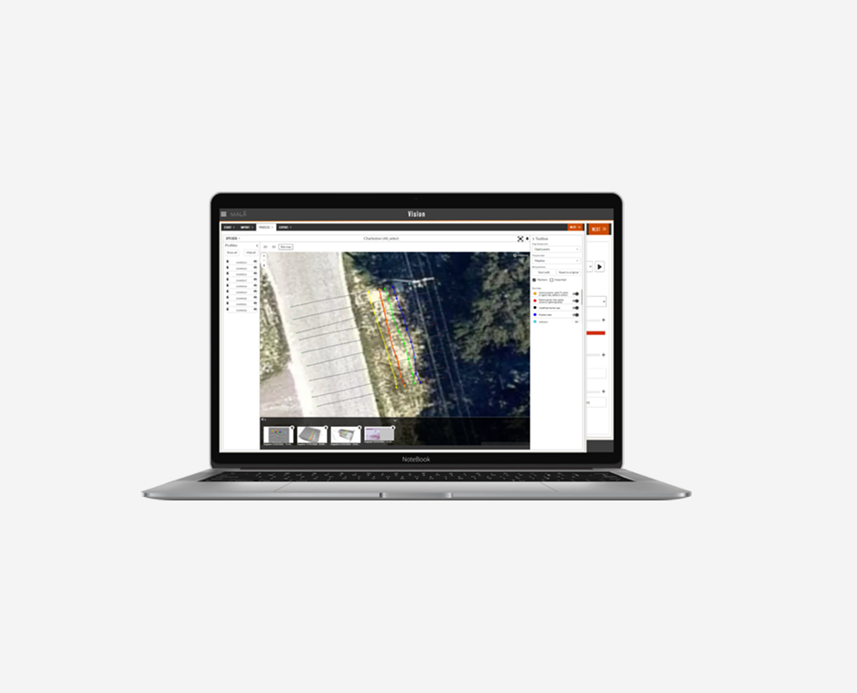
Finding utilities in Gainsborough, UK.
Built on the powerful MALÅ Vision platform, MALÅ Vision Desktop makes planning, processing, and reporting of 3D GPR array data straightforward and fast.
Working with Large GPR Datasets
Working with large datasets no longer means long waits. MALÅ Vision Desktop makes full use of your local hard drive, eliminating the need for cloud uploads. From data import to final report, the entire workflow takes minutes.
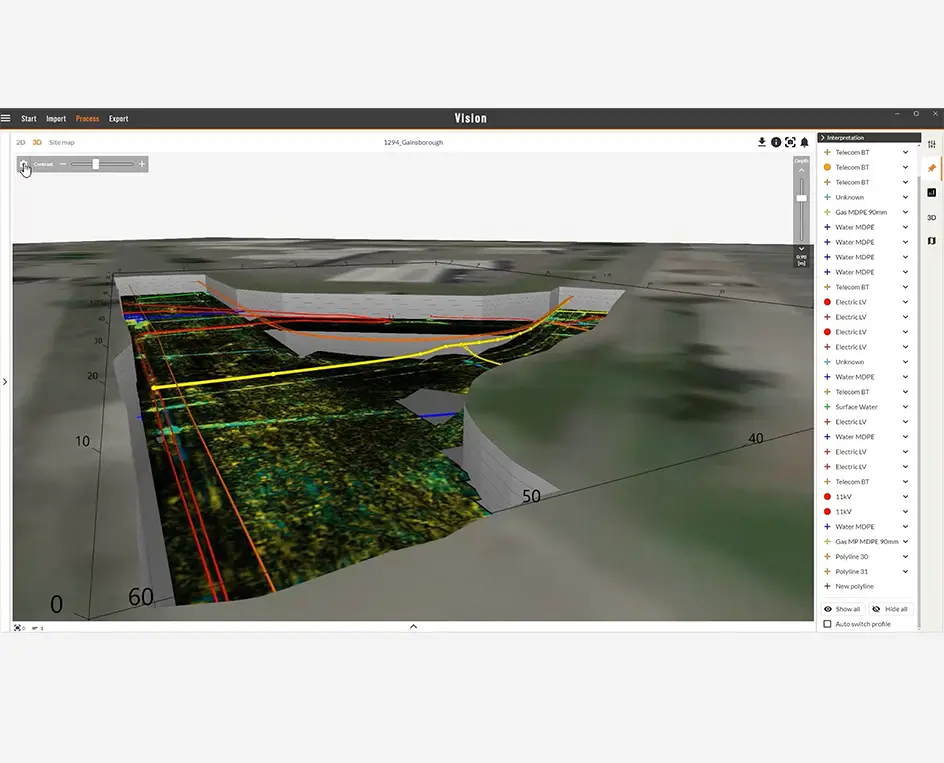
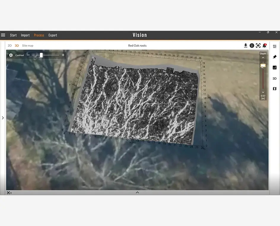
Red oak tree roots underneath the soil as seen in MALÅ Vision Desktop
To many the subsurface can feel like an unknowable place – hidden, technical, the domain of specialists. But we feel it doesn’t have to be. When you can see and instinctively understand what lies below, it becomes easier to make better decisions – whether you’re locating underground utilities, planning a dig, or protecting a tree.


Some of the features in MALÅ Vision Desktop:
- Support for handling of large 3D array data sets
- Offline capability (continuous internet access not required)
- Instant preview of imported data
- Immediate response when changing settings, filters, contrast etc.
- Optimized, efficient and intuitive workflow
- Built-in guidance
- Best in class interpolation of 3D GPR array data (proprietary algorithms)
- Fast processing of GPR array data
- Multiple options for viewing data, including PondView, TopoView and TrenchView
- High resolution satellite imagery and maps
MALÅ Vision Web: Cloud-Based GPR Analysis Software
MALÅ Vision Web is a cloud-based GPR data analysis software optimized for small to medium-sized projects. Access your data from any device, anywhere, with no installation needed. An internet connection is required.
Powered by MALÅ AI, MALÅ Vision Web offers automated interpretation support to help identify the location of buried pipes and cables – speeding up the interpretation process for experienced users and providing valuable guidance for those newer to GPR. You can then visualize the buried assets and present your results using a range of map backgrounds and providers.


Why MALÅ Vision?
Easy
MALÅ Vision is an easy-to-use GPR processing software for visualization, handling and reporting of any kind of MALÅ GPR data. The intuitive and efficient workflow help users to obtain fast results.
Reliable
Precise
MALÅ Vision is Used for:
- GPR data collected with MALÅ, GSSI, and ImpulseRadar equipment
- Utility and point target detection
- 3D grid projects
- Object mapper projects with coordinates
- Visualizing data in 3D volumes
- Exporting interpretations, markers, and polylines to DXF, CSV, and TXT
- General projects with reliable coordinate information
MALÅ Vision is continuously updated with new features and functionality.
Features
MALÅ AI is an integrated part of MALÅ Vision Web

The intuitive workflow and easy-to-use toolbox helps optimizing processing, profile handling and interpretations. Integrated with MALÅ Vision Web, MALÅ AI adds valuable help to speed up the process when interpreting larger utility projects.
Adding and removing filters, editing display effects and analysing data – MALÅ Vision makes it easier to obtain the most from your GPR project. Quickly interpret profiles using help from MALÅ AI, the auto-switch marker tool and the standardised colour tables. MALÅ AI helps making interpretation work and reporting smoother and faster.
View and Analyse from all angles
Visualise and present GPR data in trace, profile and volume view (1D, 2D and 3D). View interpretations together with Site map, 2D data, interpolated 3D images or time slices.
MALÅ Vision allows you to simultaneously view data in any possible way or instantly switch from one view to the other while working on a project. Modify your work environment to what works best for your project. All processing is done in the background, leaving you free to continue with your analysis and interpretation.
Annotations

Handle all kinds of survey information. Markers, sound, images, notes. Integrate all information for best possible results.
The more information about a site we collect in the field, the easier and better the interpretation work. MALÅ Controller App is capable of collecting images, sound, screen captures, typed notes and more in the field and this is of course fully supported by MALÅ Vision.
MALÅ Vision Web Pricing and Subscription Options
MALÅ Vision Community license is available free-of-charge. The license can easily be obtained through self-registration and the user will get immediate access to the software. MALÅ Vision Premium license is available for purchase and immediate upgrade online, from within the software. Guideline Geo will introduce new features and functionality continuously to the software.
| Tier | Data limit | Functionality | Price/month | Price/year |
|---|---|---|---|---|
| MALÅ Vision Community | 50 MB | Full | Free | Free |
| MALÅ Vision Premium | 300 GB | Full | 99 USD per month | 950 USD per year |
MALÅ Vision Community
The MALÅ Vision Community license includes the full standard software but with a limited storage of 50 MB of imported data, enough for completing smaller projects. The Community license enables any user to experience the full functionality of the software and see the benefits of using MALÅ Vision.
MALÅ Vision Premium
The MALÅ Vision Premium license includes all standard features and adds 300 GB of online storage, enabling you to handle much larger projects.
MALÅ Vision University licenses
Special arrangements are available for Universities and other academic institutes. Please contact your Guideline Geo sales representative for more information.
Contact us for a Demo
Contact us for a demo including a free and fully functional demo-license.