Electrical resistivity tomography (ERT) measurements were successfully used to investigate the geological settings for a groundwater source in Western Småland, Southern-Sweden. The ERT investigations could identify areas for further investigation with drilling, both in thicker sediment layers and in fracture zones in the bedrock, to confirm the groundwater outtake potential.
CHALLENGE
The investigation area was rather large, approximately 1600 meters times 800 meters, with both open areas, forests, buildings and roads and a highly variable topography. Information on the geological settings was required to a depth of at least 50 meters depth, with a high resolution.
RESULTS and CONCLUSIONS
All 6 profiles investigated with the Terrameter LS 2 system resulted in helpful information of the subsurface conditions. A geological interpretation was made and with this result six different areas were concluded to be interesting for closer examination with drillings. Three of them were found in areas with thick, course sediments and three in fracture zones in the bedrock.
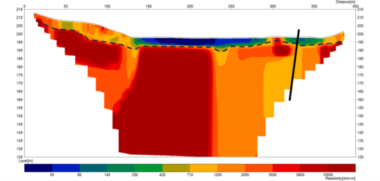
The dashed line represents the bedrock. The solid line represents the suggested drilling point, in a possible fracture zone in the bedrock. The area in the middle part of the profile, in blue, is peat land.
The dashed line represents the top of bedrock. The solid line represents the suggested drilling point, in a possible layer of glacial soil. The small blue area indicates clay.
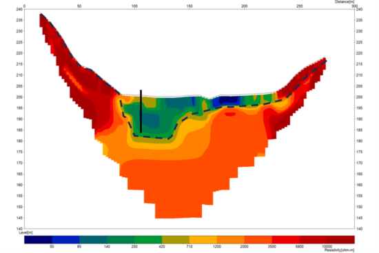
The dashed line represents the bedrock. The solid line represents the suggested drilling point, in a possible layer of glacial soil. The blue area at left indicates peat and at right clay.
Sweco AB is Europe’s leading architecture and engineering consultancy and offers services in three segments: buildings and urban areas; water, energy and industry; and transportation infrastructure. Within these segments Sweco’s experts help clients analyse, simulate, calculate and design solutions for tomorrow’s sustainable cities and communities. The business operates in eight geographical business areas covering around 15 markets in Europe. Sweco also conducts project exports to many countries throughout the world.
The field work presented in this case was carried out by Sweco Sverige AB in Gothenburg.
SOLUTION
As the investigation area was extensive and sometimes difficult to access, the ABEM Terrameter LS 2 was used, in 2D mode (so called ERT Electrical Resistivity Tomography). The ABEM Terrameter LS 2 is a compact resistivity solution, also for rougher terrain.
The resistivity measurements were made with ABEM Terrameter LS 2, with a four-cable set up and 81 electrodes. As seen the measurement conditions were quite varying, with both open terrain and forest.
For efficient data collection along profiles, multiple electrodes were placed in a line at a set distance (5 meters for high resolution). The system then automatically selects which electrodes to use for current injection and voltage readings. In a short time, a high number of data points (with varying X and Z coordinates, but a fixed Y coordinate) could be measured.
The resistivity lines were planned according to already available information on e.g., geological and groundwater maps.
As the surface conditions during measurements were partly very dry, some electrodes were watered to reduce electrical contact resistance and increase current flow.
In the investigation area six ERT profiles were collected, with a total length of approximately 2100 meters. All lines were positioned using an RTK -GNSS.