Large scale 3D GPR mapping

MALÅ 3D Imaging Radar Array (MIRA) is a high-speed, one-pass 3D GPR system and the most effective solution for large-area GPR mapping.

MIRA HDR includes our world-renowned MALÅ HDR real-time sampling technology providing ultra-fast measurements and razor sharp data. The solution seamlessly integrates acquisition, processing, QA/QC, positioning and interpretation of ground penetrating radar data.

Ground Penetrating Radar (GPR) mapping

Typical application areas


MALÅ MIRA HDR is designed for any large scale 3D mapping project. Some of the more common application areas include:

  • Large area mapping
  • Utility mapping
  • Archaeology
  • Road investigation
  • Underground Storage Tank (UST detection)


  • Unexploded ordnance (UXO)
  • Sinkhole detection
  • Bedrock mapping
  • Clandestine graves
  • General site investigations

Features

Large Area Mapping

With the highest data-channel density on the market MALÅ MIRA HDR delivers unsurpassed class-leading resolution. The MALÅ MIRA HDR produces data with less noise, at higher speeds, with more functionality using improved mechanical design and modern software. The MIRA HDR is a cost-effective 3D GPR array, optimized for mapping large areas to locate buried objects and artefacts.

Ground Penetrating Radar (GPR) mapping

MIRAsoft transmitter view with MALÅ MIRA HDR

132 data channels

In standard configuration the MIRA HDR 3D GPR array uses a 500 MHz centre frequency, 11 transmitters and 12 receivers. The system is normally set up to collect 22 data channels but the system is capable of collecting up to 132 data channels simultaneously since it allows data collection from any transmitter-receiver combination in the whole array.

MIRA HDR delivers 32-bit output even at highway speeds, producing exceptional data quality. The 6.5 cm channel spacing, allows for the collection of precise, high resolution data. 

MALÅ HDR (High Dynamic Range) GPR

The MALÅ MIRA has been redesigned to take full advantage of the MALÅ HDR technology, giving you the best possible GPR data quality, resolution, bandwidth . 

The MALÅ HDR technology produces data with significantly lower noise levels, compared to traditional GPR systems. A lower noise floor gives a wider bandwidth when compared to conventional time-interleaved systems. This removes more of the background interference, giving sharper data with higher contrast, and the ability to see deeper than non-HDR systems. 


Guidleine Geo MALÅ MIRA HDR bell curve w arrows

MALÅ carrier solutions

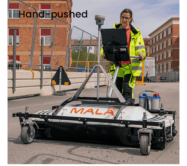
There are several different types of carrier solutions for the MALÅ MIRA HDR. Some are intended to be pushed and other to be pulled and all carrier options have specific advantages for certain types of field work. Guideline Geo is continuously listening to our customers to help modify existing solutions to specific needs but the four official carrier solution available for the MIRA HDR today are:

  • MIRA HDR Field trailer
  • MIRA HDR Road trailer
  • MIRA HDR Front-mounted
  • MIRA HDR Hand-pushed

Look at the images (left) of the various carrier solutions and contact us for more information.

Software

MIRA Controller

With the MIRA Controller acquisition software, you will experience a modern and easy-to-use interface with integrated navigation aids helping you to maximize the quality of your measurements. MIRA Controller tracks the performance and data collection in detail helping you to maintain the correct speed and course.   

MIRA Controller can also be used to view and edit previous projects; it exports to several formats for integration with other software packages.  

Download now   


Resources

Contact us to receive a quote

  • This field is for validation purposes and should be left unchanged.