A multi-channel GPR array, such as a MALÅ MIRA HDR system, will give you the highest possible resolution over complex archeological features of many different types. With a MIRA HDR you collect a large number of densely arranged parallel profiles in one single swath, meaning that data can be easily transformed to a high-resolution 3D result.
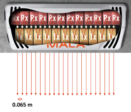
With a single channel system LINK TO 2D GPR and Archaeology, you measure one 2D line at the time, compared to a multi-channel GPR array where you have several transmitters and receivers in one single box. This gives you, on a MIRA HDR, 22 parallel lines at a time, instead of one.

For archeological applications this high resolution is often a must, especially when mapping minor post holes, subtle wooden features or complicated building remains. With a multi-channel GPR array, it is also sufficient to make the measurements in only one direction.
For archaeological applications the following is good to consider before making measurements with a multi-channel GPR array:
Ground conditions
As a multi-channel GPR array is comparably expensive to rent and buy, and also bulky to transport, it can be good to do some 2D GPR test lines in the proposed investigation area. If data quality looks good, both in terms of conductivity, and possibility to identify the intended targets, the likelihood of completing a successful multi-channel GPR will also increase.
Investigation area
Multi-channel GPR arrays are large, and heavy, compared to a 2D GPR system. This means that the investigation area needs to be comparably smooth and open for the array measurements. Vegetation should be low as results from these ground-coupled GPR antennas are best when the distance between the ground and the antenna casing is small. If there are numerous obstacles, such as trees and fences, achieving comprehensive coverage becomes more complicated and requires more field time. If obstacles are too densely situated, the antenna box may not be able to traverse the survey area at all.
Moving the antenna array
Most multi-channel GPR arrays can be hand-pushed or pulled but this is not recommended for larger areas or if the ground surface is rough. Then it is much more efficient to tow or push the GPR array with a vehicle, such as a car, quadbike, small tractor or utility vehicle. The smaller the vehicle, and the tighter its ‘turning circle’ is, the easier survey becomes.
Positioning
For high-resolution results the positioning needs to be accurate. The GPR array can be positioned using either Total Station or an RTK-GPS system. The Total Station needs to be a self-tracking type and for the RTK-GPS either a ‘base + rover’ system or a rover with GSM-correction will work fine (provided there is sufficient mobile phone coverage across the site for the latter system to receive corrections). Marking of measured swaths can be made during measurements to keep the swaths side by side to avoid excessive gaps between the data. This aid is also available in software used for data collection.
One or two profile directions
As a multi-channel GPR array creates a data volume made up of extremely dense profiles, where line spacing and trace interval are similar, the survey swathes need only be collected in one direction.
Post-processing Multi-channel data are most often compiled into a 3D volume and processed as a whole, with the possibility to look at time-slices from different depths. Depending upon the software used, you can also cut your data in almost any direction, create iso-surfaces and/or apply topographic corrections. However, do not forget to check the single 2D lines, these are your primary data and contain plenty of information as well!
More to read
Application Area
Help articles
Case stories
Unsealing the legendary Tomb Of Christ
The-Holy Sepulchre Case story (PDF)
Viking ship discovered in Norway