An external GNSS (Global Navigation Satellite System) device (GPS, GLONASS etc.) can be connected to your GPR equipment by a cable or be connected wirelessly by Bluetooth, depending on the GPR system you use.
All MALÅ GPR systems can be connected to an external GNSS system which will provide positions (coordinates) to your measured radar data. How this is accomplished differs from system to system (see explanation below).


For all systems the GNSS data must:
- Be output in NMEA 0183 GGA format
- Have the same baud rate (speed of communication) settings as the GPR system.
The GGA format contains information on the position of the GNSS receiver, time and date of received signals as well as a number indicating the accuracy (quality) of the signal. With this information, the MALÅ GPR data can be assigned global coordinates. A typical coordinate file created by the GPR system (often called*.cor) gives you the following information:
- Trace number (starts from trace 1)
- Date and time
- Latitude and Longitude (in WGS84)
- Height (m.a.s.l.)
- HDOP (horizontal dilution of precision, a quality number, where low values indicate better quality)

Note! The NMEA strings have an identifier at the start which displays which satellite system is in use. If the system only outputs information from the American GPS system, the output signal is named $GPGGA. If it utilizes information from all available international GNSS systems it is named $GNGGA (i.e., from Russian GLONASS, American GPS, European GALILEO system or Chinas BeiDou system). Our earlier generations of GPR systems could only handle information collected in $GPGGA format while the more modern GPR systems can read the $GNGGA format as well.
Note! If you need an RTK correction for your external GNSS measurements (i.e. better precision with aid from a base station network), make sure to use a base-rover set up or setup up a subscription service in the country where you are working to receive the corrections through the mobile network. This can easily be accomplished by having a SIM-card installed in your GNSS device. For some GNSS systems you can also share your mobile phone network by hotspot and receive the correction this way.
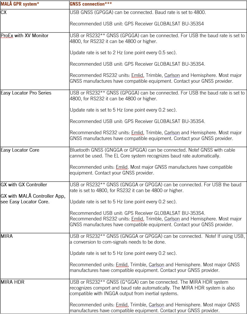
(click to enlarge)
* More information on GNSS connections can also be found in the User Manuals https://www.guidelinegeo.com/support-service-advice-training/resource-center/
** 9-pin D-sub connector
*** Always check our webpage www.guidelinegeo.com for news and updates