You can find bedrock and determine whether its depth is consistent or varying through the use of one or several different geophysical techniques or by geotechnical investigations such as drilling or digging.
The geophysical methods will provide input with more or less continuous data but may not be as precise as the geotechnical, point-wise, drilling and digging alternatives. Most often a combination of geophysical investigations with traditional geotechnical investigations is the best and most efficient way to find the bedrock. In this way you get more continuous information (i.e. more data points) and can place the relatively expensive and time-consuming drilling/digging at the most critical locations. The combined approach is often a pre-requisite to build a 3D bedrock model which can be used for planning different types of infrastructure projects including foundation designs, roads, railroads, larger constructions etc.
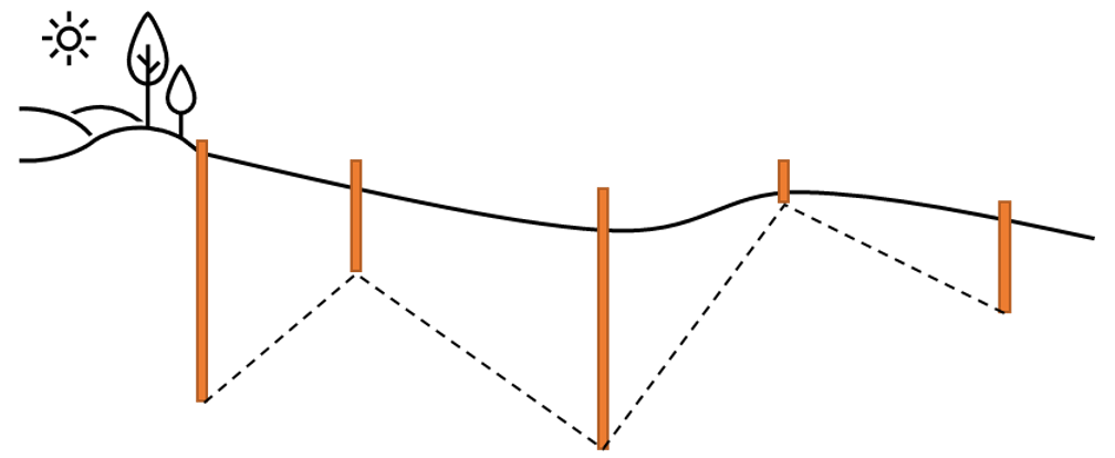
Bedrock investigation with geotechnical drilling only and the assumptions made about bedrock position.
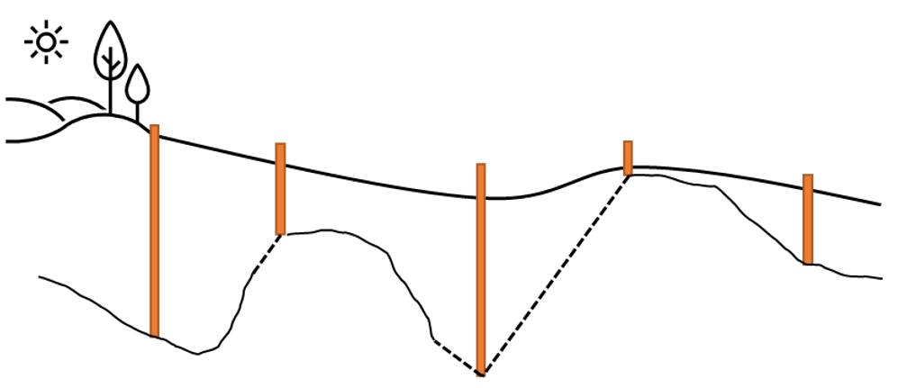
Bedrock investigations with both geophysical measurements and geotechnical drilling give a more correct picture of the subsurface conditions.
Which geophysical method to use depends on the geological conditions at the site:
- What type of overburden do you have, i.e. soil types above the bedrock?
- What is the expected depth range to the bedrock?
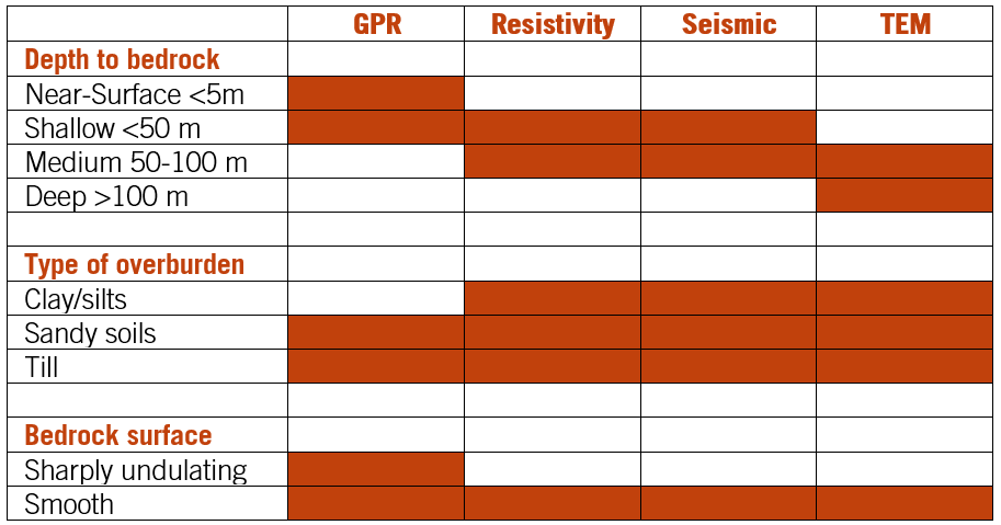
he table below is a good starting point to choose between the different geophysical methods available from Guideline Geo. More information on the different methods can be found here:
GPR RES TEM SEIS Application area Bedrock
Other considerations to make before deciding how to find the bedrock can be:
- GPR is suitable in non-conductive conditions (e.g. without clayey soils) down to approximately 30-50 meters.
- TEM is unsuitable in urban areas due to sources of electromagnetic disturbance.
- Resistivity requires galvanic contact via electrodes of some description which can be both hard and time consuming in environments with bare rock or asphalt etc.
- If an active (as opposed to passive) seismic method is to be employed the source needs some consideration; it needs to be big enough to get the energy to and from the desired depth and there may be legislative or environmental constraints upon how this is achieved.
- TEM or VES may be sufficient for broad prospection, but they are point-by-point methods whereas GPR, ERT and seismic surveys provide more detailed results.
- TEM is not well suited to differentiating between highly resistive geological units; the method responds better to conductive layers, but an interface between resistive and conductive should be easy to determine.
- 1D methods (VES, TEM, VSP) are not well suited to identifying laterally confined features like fracture zones and intrusions compared to 2D methods which offer greater detail.
With geophysical methods you can also investigate the character of the bedrock or other features within it, including:
- Bedrock topography (GPR, resistivity, seismic, TEM)
- Fracture and fault zones (GPR, resistivity, seismic)
- Cavities (GPR, resistivity, seismic)
- Ores / Mineral deposits (GPR, resistivity, TEM)
- Fractures in tunnels / tunnel walls (GPR)
- Lithology or bedrock type / change (GPR, resistivity, seismic, TEM)
- Mechanical parameters / pressure and shear wave velocities (seismic)
More to read
Application areas
https://www.guidelinegeo.com/application-areas/
Methods
https://www.guidelinegeo.com/ground-penetrating-radar-gpr/
Case Stories
https://www.guidelinegeo.com/solutions/case-stories/
Products
https://www.guidelinegeo.com/mala-ground-penetrating-radar-gpr/