Ground Penetrating Radar – GPR

What is Ground Penetrating Radar?

Ground Penetrating Radar (GPR) is a non-destructive and rapid geophysical method that operates by transmitting electromagnetic waves from an antenna and reflects off layers and objects hidden in the ground. These reflections are collected as data which generates an image of the subsurface.


explore our range of gpr products


A typical ground penetrating radar system configuration consists of one or more antenna elements, a control unit, and a monitor or external Tablet/PC, for storage and display of data.

Why do I need a ground penetrating radar system?

A GPR system is an efficient tool and commonly used when digging, coring, or drilling is not allowed, or needs to be reduced to minimize cost. Ground penetrating radar can quickly add useful information when other sparsely sampled information is not detailed enough. Our MALÅ range of ground penetrating radar solutions covers the applications of multiple geological applications as well as applications for mapping utilities and other subsurface objects and internal structures of constructions.


The most common application areas where where ground penetrating radar systems can be used includes:


  • Utilities: GPR can be used to locate and map the depth of water, gas, electric, communication lines, sanitary and storm sewers or unknown and abandoned pipes. GPR is also efficient for mapping the location of underground storage tanks  and for pre-studies for horizontal directional drilling (HDD). How to locate underground utilities
  • Concrete investigation: GPR can be used to locate and map the depth of rebars and other installations in concreteGPR is als well suited, for instance, to map the thickness of concrete slabs/elements, void detection and  concrete fracture mapping. Read more here
  • Roads and Railways: GPR is widely used for mapping road and asphalt layering, as well as railroad ballast surveys. Further on GPR is suitable to investigate the internal structure of roads and railways and investigate the geological investigations prior to construction. GPR is also commonly used for bridge decks surveys and runway investigations at airports. Read more about road investigation
  • Archeology: GPR is often used to map archaeological landscapes, sites, features and objects. Read more about archeology
  • Geology: GPR can be used fo stratigraphic mapping, structure analysis, cavity and sinkhole detection, depth to bedrock investigations, mapping of bedrock fractures, mining hazards etc. Learn more about bedrock mapping
  • Water: GPR is well suited to map lakes and rivers, for bathymetry investigations as well as investigating the river and  lake floor structures. GPR can also be used for geological investigations for the detection of ground water.


  • Earth and concrete dams: GPR can be used to investigate the internal structure and layer of dams, as well as voids. Further on GPR assist in mapping concrete and rebars.
  • Tunnels and Mining: GPR is used for fracture detection, structural investigations and concrete thickness evaluation.
  • Environmental: GPR can aid in mapping hazardous waste, underground storage tanks and other utilities.  Further on it is suitable to use a GPR to map the bedrock surface for estimating flow directions and also for lake sediment surveys.
  • Military: GPR is often used for UXO (unexploded ordnance) detection, runway integrity analysis and clearing of trenching routes etc.
  • Ice and Snow: GPR is an excellent tool for structure analysis of ice and snow, as well as ice and snow thickness estimations and crevasse detection etc. Read more here

How does a ground penetrating radar work?

Ground penetrating radar work, n principle, similar to a fish-finder (or echolocation device) in a boat. The transmitter antenna radiates repetitive short-duration electromagnetic signals into the subsurface as the antenna moves across the surface. Electromagnetic waves are reflected back to the receiver by interfaces between materials with differing electrical properties, e.g. sand and bedrock, or rebar and concrete. The collected traces (also called scans) of the reflections form a ‘radargram’, the result of the GPR investigations, and is presented to the user, in real-time, as data is being collected.

The depth and resolution that can be achieved with ground penetrating radar depends on the frequency of the transmitted electromagnetic pulse. A higher frequency results in higher data resolution, whilst a lower frequency results in better depth penetration.

Primarily the depth/resolution requirements and the soil conditions at the site determine the choice of antenna frequency. The table below is a guide when selecting antenna frequency based on the depth interval of interest. The table is calculated using recommendations from D.J. Daniels (Ground Penetrating Radar, 2004) where the depth of penetration before the full energy of the transmission is lost, is defined as 20 wavelengths or less.

Note! It is important to remember that this is only a guide and the results at a certain site will very much depend on local conditions, i.e. the specific electrical properties of the media investigated. For instance, in ice and snow the depth penetrations can be considerably higher.

Antenna centre frequency (MHz) Suitable target size (m) Approx. max. penetration​ depth (m) at 100µs/m​
25 1 80
50 0.5 40
100 0.1 20
250 0.05 8
500 0.04 4
750 0.03 2.7
1000 0.025

2

To improve the performance of GPR antennas Guideline Geo / MALÅ has developed and patented the HDR (High Dynamic Range) technology. The HDR technique will increase the bandwidth of an antenna to roughly 120% compared to a non-HDR capable antenna. As a result, the systems will have better depth penetration and resolution than a comparable non-HDR antenna.

As a rule of thumb the resolution decreases with depth. The objects to be mapped need to be at least 10% of the investigation depth. This means that small objects cannot be detected at larger depths with ground penetrating radar.

CAN GPR SURVEYS BE CARRIED OUT ON GROUND OR IN GROUND?

GPR surveys can be applied both on the ground surface or in boreholes. For the two different types of investigations there are several different antenna frequencies available. GPR systems can also be mounted on, for instance, a drone for air-borne investigations.


How does a ground penetrating radar work?


How does a ground penetrating radar work?

For GPR ground surveys, depending on the application and field environment, the GPR antennas can be pulled or pushed, by hand or vehicle. Choose the sled for a pull-optimized system, or select a rough terrain cart for a push-optimized system. The ground penetrating radar system can most often be adjusted to fit your purpose, for easy data collection in any environment.

For GPR borehole surveys the antennas can be applied in one borehole (single hole measurements) or in two boreholes (cross-hole measurements)

Read more about borehole GPR

Considerations

Ground Penetrating Radar is a very versatile geophysical method, reaching from rebars to deep ice investigations. However, like any geophysical method, it is useful to understand the limitations. For GPR the conductivity of the ground/construction is critical. If the conductivity is too high, the electromagnetic waves are efficiently subdued, energy gets lost and no information is gained from depth.  

The conductivity can be a problem in areas with clayey, and silty soils, salt or brackish water (both ground water and lake/sea/river), in areas with dissolved ions (different types of ground contamination), in newly lain concrete (due to dissolved ions), newly salt sprinkled roads 

Most often a short test measurement or knowledge of the electrical conductivity can tell if ground penetrating radar is a way forward or if another investigations technique should be considered.  

As a rule of thumb, ground penetrating radar is good for any geological medium when the resistivity is above 100 Ohm-m (conductivity below 10 mS/m). GPR will, in most cases, be ineffective in a geological medium with a resistivity lower than 50 Ohm-m (above 20 mS/m).    

Note! GPR waves do not penetrate metallic objects but sometimes can give a typical signature, so called “ringing”, which can be used to separate metallic objects from non-metallic objects.

Discover application areas for ground penetrating radar

As a world leader in geo-technology, Guideline Geo and MALÅ is the perfect partner for your ground penetrating radar (GPR) solution needs. MALÅ has a history of high-tech innovation going back to the 1930´s and is the premier provider of GPR control units, antennas, software, and accessories around the world. 

We also offer support, training and rental options for all systems and equipment so you can focus completely on the planning and execution of your project. We combine service and knowledge with world-leading geophysical solutions. 
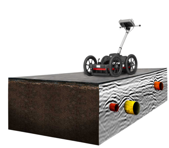
GPR Method 

Ground penetrating radar (GPR) is a non-destructive and rapid geophysical method that operates by transmitting electromagnetic waves form an antenna and reflects off layers and objects hidden in the ground. A typical ground penetrating radar system consists of one or more antenna elements, a control unit, an external Tablet/PC or a monitor, for storage and display of data. Ground penetrating radar offers an efficient way of investigating both the ground and constructions, with user-friendly one-man operated equipment. Depending on the application, you have a large selection of different MALÅ GPR solutions to choose from which will solve your investigation needs, both in terms of antenna frequency and number of data channels.  

GPR Applications 

GPR have a very wide range of applications, from measurements of the subsurface to investigations of constructions. The most common applications are: 

  • Utilities 
  • Concrete investigations 
  • Roads and Railways 
  • Archaeology 
  • Geology 
  • Water 
  • Earth and concrete dams 
  • Tunnels and mining 
  • Environmental 
  • Military 
  • Ice and snow 


MALÅ geophysical products 

The MALÅ range of products facilitates the mapping of everything from shallow rebars to investigations of hundreds of meters of ice.  

MALÅ Easy Locator Core is the state-of-the-art intelligent GPR solution for utility locating professionals. It offers a seamless workflow from the field to the office, through the easy-to-use software solutions MALÅ Controller App and MALÅ Vision. 

MALÅ Ground Explorer (GX) is an integrated GPR solution with a wide range of antenna options and measuring devices. It is wireless and works with the MALÅ Controller App or a dedicated data collection field controller.  

MALÅ MIRA HDR is a 3D GPR array for cost-effective mapping of large areas to locate buried objects and features. The system is ultra-fast and delivers high-density razor-sharp data. 

MALÅ Easy Locator WideRange is, with its dual channel antenna, the go-to choice for both shallow high-resolution surveys and deep utility locating projects.  

MALÅ GeoDrone is an airborne GPR solutions for efficient field work, designed specifically for data collection in remote hazardous and inaccessible areas.  

MALÅ MIRA is a 3D GPR array providing a cost-effective solution for large-scale mapping and subsurface object identification.  

MALÅ ProEx is fully compatible with a broad range of MALÅ GPR antennas and offers a flexible and very versatile GPR solution from concrete investigations to deep geological and glaciological investigations. 

MALÅ Concrete Explorer (CX) is an easy-to-use GPR system designed for concrete investigations and non-destructive imaging of man-made structures.  

Contact us to get a quote 

If you have any questions, you are always welcome to contact our customer service or get in touch with our 24/7 sales support. We want to be close to you as a customer and therefore we aim to respond as soon as possible. Get in touch with our dedicated Global Sales and Applications support teams by filling out the webpage contact form.